|
|
||
|
|
|
|
Hydrographic and Geophysical Surveys in the Celtic Sea and Atlantic Ocean during 2019Marine
Notice No. 08 of 2019
The Department of Transport, Tourism and Sport has been advised that hydrographic and geophysical surveys will be undertaken in the Celtic sea and Atlantic Ocean under the INFOMAR (Integrated Mapping for the Sustainable Development of Ireland’s Marine Resources) programme, between April and October 2019.
The vessels involved are as follows, Marine Institute vessels: the ‘RV Celtic Voyager’ (Callsign: EIQN) and the ‘RV Celtic Explorer’ (Callsign: EIGB) and Geological Survey Ireland Vessels: the ‘RV Keary’ (Callsign: EI-GO-9), the ‘RV Geo’ (Callsign: EI-DK-6), the ‘RV Mallet’ (Callsign: EI-SN-9), and the ‘RV Lir’ (Callsign: EI-HI-2).
The ‘RV Celtic Voyager’ and the ‘RV Celtic Explorer’ will be towing a magnetometer sensor with a single cable of up to 200 metres in length. The vessels will display appropriate lights and markers. The vessels will be listening on VHF Channel 16 throughout the course of the surveys.
The Survey periods will be as follows:
R.V. Celtic Explorer 21/09/2019 – 08/10/2019 18 days Celtic Sea
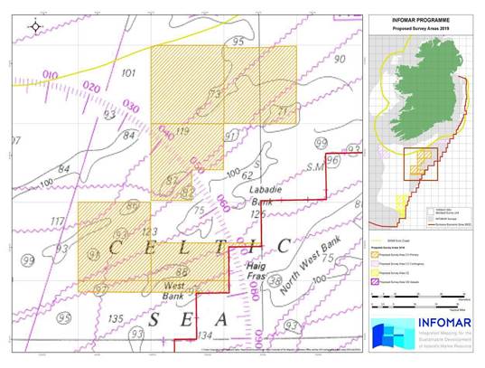
Figure 1: Overview of 2019 offshore survey areas Generic coordinates where survey operations are expected to take place are provided below. Detailed coordinates of each survey polygon can be provided on request.
1. Celtic Sea
(i) The R.V.’s Keary, Geo, Mallet and Lir are expected to carry out survey operations in the northwest Celtic Sea and inshore County Cork, stretching from the Old Head of Kinsale to Cape Clear.
The areas are denoted by the purple coloured hatched areas of the image below (Figure 2) , with the offshore section bound by the following coordinates;
And the inshore section spanning from:
Figure 2: R.V.’s Keary, Geo, Mallet and Lir Celtic Sea survey areas.
(ii) The R.V. Celtic Voyager is expected to carry out survey operations in the Celtic Sea, within the orange hatched area of the image below (figure 3), bounded by the following coordinates:
Figure 3: R.V. Celtic Voyager Celtic Sea primary survey area. (iii) The R.V. Celtic Voyager is expected to carry out survey operations in the Celtic Sea, within the pink hatched area of the image below (Figure 4), bounded by the following coordinates;
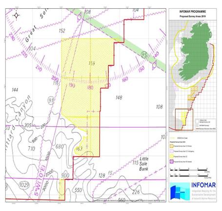
Figure 4: R.V. Celtic Voyager Celtic Sea contingency A survey area. (iv) The R.V. Celtic Explorer is expected to carry out survey operations in the Celtic Sea, within the yellow hatched areas of the image below, bounded by coordinates;
Figure 5: R.V. Celtic Explorer Celtic Sea survey areas. 2. Atlantic Ocean
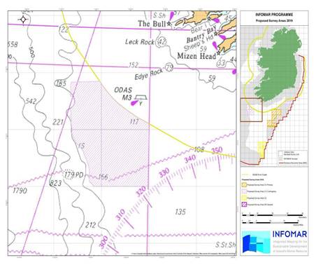
The R.V. Celtic Voyager is potentially going to carry out survey operations in the Atlantic Ocean, southwest of counties Cork and Kerry within the pink hatched area of the image below, bounded by coordinates;
Figure 6: Celtic Voyager Atlantic Ocean contingency B survey area.
INFOMAR Charts and information on a bay basis can be found on the website at: http://www.infomar.ie. Images, Bathymetry, Backscatter, Shaded Relief, Classification .pdfs are available.
INFOMAR offshore & Geological Survey Ireland onshore digital data can be downloaded via https://jetstream.gsi.ie/iwdds/index.html
Enquiries/Contact
Enquiries or supporting information in relation to the above programme should be directed by email to info@infomar.ie , or by phone to Marine Institute +353 91 387200 or Geological Survey Ireland +353 1 6782000.
All mariners are reminded of their responsibilities under the International Collision Regulations and are reminded of Marine Notice No. 17 of 2007, which gives general advice in relation to the activities of vessels engaged in survey work for hydrographic, seismic, fishing research and underwater operations.
The International Regulations for Prevention of Collisions at Sea (COLREGS) are implemented in Irish law by the Merchant Shipping (Collision Regulations) (Ships and Water Craft on the Water) Order 2012 [S.I. No. 507 of 2012], and the Signals of Distress (Ships) Rules 2012 [S.I. No.170 of 2012]. See Marine Notice No. 06 of 2013. These Statutory Instruments may be purchased by mail order from Government Publications, Office of Public Works, 52 St. Stephen’s Green, Dublin 2. Tel: (01) 6476834/1890213434. They are also available online at: www.irishstatutebook.ie.
Marine Notices are issued purely for maritime safety and navigation reasons and should not be construed as conferring rights or granting permissions.
Irish Maritime Administration, Department of Transport, Tourism and Sport, Leeson Lane, Dublin, D02 TR60, Ireland.
For any technical assistance in relation to this Marine Notice, please contact: The Marine Survey Office, Leeson Lane, Dublin, D02 TR60. tel: +353-(0)1-678 3400. For general enquiries, please contact the Maritime Safety Policy Division, tel: +353-(0)1-678 3418. Written enquiries concerning Marine Notices should be addressed to: Maritime Safety Policy Division, Dept. of Transport, Tourism and Sport, Leeson Lane, Dublin, D02TR60 Ireland. Email: marinenotices@dttas.gov.ie or visit us at: www.dttas.gov.ie |
|
||||||||||||||||||||||||||||||||||||||||||||||||||||||||||||||||||||||||||||||||||
|
Europe: Port Aleria, Rosnakilly, Kilmeena, Westport, Co. Mayo, Ireland - USA: PO Box 726, Mahwah, NJ 07430 All content on this site is subject to Copyright© - All rights reserved. Contact us - Advertising - Privacy - Terms & Conditions - Copyright & Trademark - Webmaster |