|
|
||
|
|
|
|
C-Map Launches High Resolution Coastal BathymetryMost Detailed Chart Data Available Helps Coastal Anglers Find Fish Fast
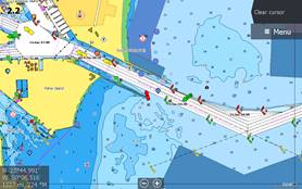
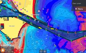
Coastal HRB Data Before V42 and Coastal HRB Data V42 Turned On
C-MAP, a leader in digital marine cartography and cloud-based mapping, announced today the release of a new feature for C-MAP chart cards – Coastal High Resolution Bathymetry (HRB).
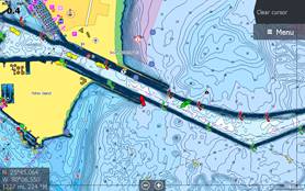
Coastal HRB Data Before V42 and Coastal HRB Data V42 Turned On
Offering anglers the latest and most detailed contour data for their C-MAP charts, Coastal HRB enhances current MAX-N+ cards with the highest resolution depth contour detail available. Combined with the custom depth shading available in all Navico chartplotters, it is especially helpful to fisherman who are looking to highlight those areas where fish gravitate. Available now, Coastal HRB comes with new chart purchases from data version v42.
“High Resolution Bathy gives C-MAP users the option to add another layer of more detailed contour data that reveal to anglers locations that are attractive to fish,” said Leif Ottosson, CEO, Navico. “After listening to our customers, we know that detail is important for planning routes and trolling, however it can be distracting when on the move. Our new HRB also allows users to turn off the layer for a cleaner look while navigating.”
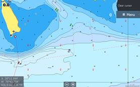
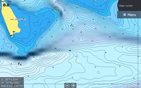
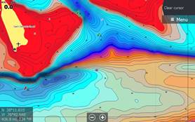
Coastal HRB and Custom Depth Shading Turned On
The Coastal HRB is available for the following C-MAP MAX-N+ titles:
For more information on the new Coastal HRB, please visit www.c-map.com.
|
|
|
|
Europe: Port Aleria, Rosnakilly, Kilmeena, Westport, Co. Mayo, Ireland - USA: PO Box 726, Mahwah, NJ 07430 All content on this site is subject to Copyright© - All rights reserved. Contact us - Advertising - Privacy - Terms & Conditions - Copyright & Trademark - Webmaster |