|
|
||
|
|
|
|
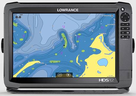
C-Map to Create New Insight Chart Options
C-MAP Insight Pro gives both coastal and freshwater anglers powerful features designed to enhance their time on the water. These include high-definition 1- to 3-foot depth contours for thousands of lakes and bodies of water — many enhanced with shaded depth contours that make it easy to pinpoint productive areas. Additional angler-specific features include a custom color palette for user-defined depth ranges, state fish and wildlife regulations/fishing records and a wealth of Fishing Hot Spots® POIs and lake-specific fishing tips and techniques. Exclusive C-MAP High Resolution Bathy (HRB) chart detail is a powerful ally for coastal anglers. These charts also provide boaters with many of the advanced navigation features C-MAP is known for, including an extensive Harbor Charts and Ports Info database, Easy Routing™ for faster, safer navigation and Active Captain® crowd-sourced POIs. New C-MAP Insight Pro charts deliver all this data and content on a single SD card covering the contiguous United States.
C-MAP Lake Insight HD offers all the Lake-related features and content of C-MAP Insight Pro, along with additional popular C-MAP features including Satellite Image Overlay and Aerial Imagery for enhanced situational awareness and a “bird’s eye” Perspective View chart presentation.
These new charting packages will be offered as both an option and embedded cartography for Lowrance®, Simrad® and B&G® displays starting in 2017 and, as a result of the further development of the Insight offering to a broader audience of boaters and fishermen, Raymarine and Furuno customers will be able to access Insight products when made available in upcoming C-MAP 4D releases.
“Our goal has always been to offer the best chart value to our customers,” said Egil Aarstad, CEO, C-MAP. “We are leveraging the equity of Navico Insight data and by combining it with our proven chart detail, popular navigation features and graphic presentation, we are changing the game for coastal and freshwater anglers. We are very excited about having these products available on Navico platforms as well as making them available to a broader OEM market and boating audience in early 2017.”
For more information on C-MAP Insight Pro and C-MAP Lake Insight HD, or the complete line of C-MAP Light Marine and Commercial products, visit www.c-map.com. Attention Sailing Organizations & PR Agencies: |
|
|
|
Europe: Port Aleria, Rosnakilly, Kilmeena, Westport, Co. Mayo, Ireland - USA: PO Box 726, Mahwah, NJ 07430 All content on this site is subject to Copyright© - All rights reserved. Contact us - Advertising - Privacy - Terms & Conditions - Copyright & Trademark - Webmaster |