|
|
||
|
|
|
|
Hydrographic and Geophysical Survey off the Mayo Coast, The Celtic Sea and The Irish Sea
Marine Notice No. 11 of 2016
Notice to all Shipowners, Fishing Vessel Owners, Agents, Shipmasters, Skippers, Fishermen, Yachtsmen and Seafarers
The Department of Transport, Tourism and Sport, has been advised that a hydrographic and geophysical survey operation will be undertaken by INFOMAR for the Sustainable Energy Authority of Ireland (SEAI) off the Mayo coast, in the Celtic Sea and also in the Irish Sea between the 21st March and 30th October. The R.V. “Celtic Voyager” (Callsign EIQN), the R.V “Celtic Explorer” (Callsign EIGB), the RV “Keary” (Callsign EIGO9), the RV “Geo” (Callsign EIDK6) and the RV “Tonn” (Callsign: EIPT7) are expected to carry out survey operations within the areas of the images below.
Celtic Sea area:
Generic coordinates where survey operations are expected to take place are provided below. Detailed coordinates of each survey polygon can be provided on request
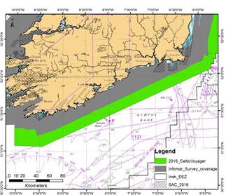
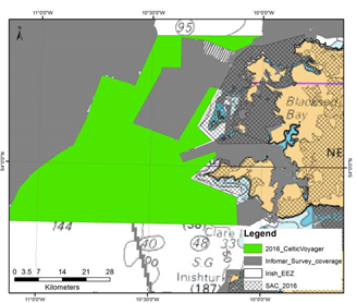
The R.V. Celtic Voyager is expected to carry out survey operations within the green area of the image below, bounded by coordinates:
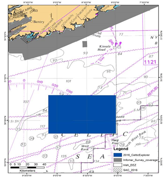
The R.V. Celtic Explorer is expected to carry out survey operations within blue area of the image below, bounded by coordinates: image below, bounded by coordinates:
The vessels will display appropriate lights and markers. The vessels will be towing equipment including a magnetometer sensor with a single cable of up to 100m in length.
Mayo Coast: The R.V. Celtic Voyager is expected to carry out survey operations within the green area of the image below, bounded by coordinates;
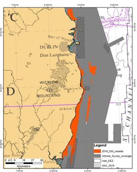
Irish Sea: The R.V.s Keary, Geo and Tonn are expected to carry out survey operations in the Irish Sea. Survey effort will initially focus in the area between Dublin and Drogheda/Carlingford and later on extend further south, offshore Co. Wicklow and Wexford. The vessels will display appropriate lights and markers during the works. Survey areas are shown in the orange in the image below, bounded by coordinates;
For additional information and product downloads
INFOMAR Charts and information on a bay basis can be found on the website at: http://www.infomar.ie. Images, Bathymetry, Backscatter, Shaded Relief, Classification .pdfs are available. INFOMAR offshore & GSI onshore digital data can be downloaded via https://jetstream.gsi.ie/iwdds/map.jsp
Please contact Marine Institute Contact Press Office: +353 (0)91 387 200 Geological Survey of Ireland: Archie Donovan +353 (0)1 6782000
The vessels will be listening on VHF CH 16 throughout the project.
All mariners are reminded of their responsibilities under the International Collision Regulations and are reminded of Marine Notice No. 17 of 2007, which gives general advice in relation to the activities of vessels engaged in survey work for hydrographic, seismic, fishing research and underwater operations.
The International Regulations for Prevention of Collisions at Sea (COLREGS) are implemented in Irish law by the Merchant Shipping (Collision Regulations) (Ships and Water Craft on the Water) Order 2012 [S.I. No. 507 of 2012], and the Signals of Distress (Ships) Rules 2012 [S.I. No.170 of 2012], see Marine Notice No. 06 of 2013. These Statutory Instruments may be purchased by mail order from Government Publications, Office of Public Works, 52 St. Stephen’s Green, Dublin 2 D02 TR60. Tel: (01) 6476834/1890-213434 and are also available online at: www.irishstatutebook.ie.
Irish Maritime Administration, Department of Transport, Tourism and Sport, Leeson Lane, Dublin 2, Ireland.
Attention Sailing Organizations & PR Agencies: |
|
|||||||||||||||||||||||||||||||||||||||||||||||||||||||||||||
|
Europe: Port Aleria, Rosnakilly, Kilmeena, Westport, Co. Mayo, Ireland - USA: PO Box 726, Mahwah, NJ 07430 All content on this site is subject to Copyright© - All rights reserved. Contact us - Advertising - Privacy - Terms & Conditions - Copyright & Trademark - Webmaster |