|
|
||
|
|
|
|
Notice of Demersal Monkfish and Megrim survey off the North Coast of Ireland.Marine Notice No. 07 of 2016
Notice to all Shipowners, Fishing Vessel Owners, Agents, Shipmasters, Skippers, Fishermen, Yachtsmen and Seafarers
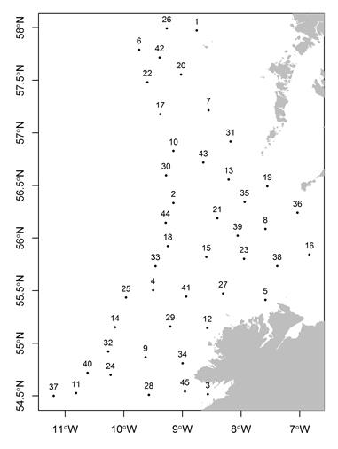
Figure 1:
Figure 1: Map of planned survey stations (black dots) labelled with Station ID number.
Table 1: Survey Stations are located within a 3nm radius of the following coordinates:
The survey will be conducted by the R.V. “Celtic Explorer” (Callsign: EIGB). The vessel will display all appropriate lights and signal during the survey and will also be listening on VHF Channel 16. The vessel will be towing a commercial monkfish demersal trawl during fishing operations.
The Marine Institute request commercial fishermen to keep a 3 nautical mile area around the tow points clear of all commercial gear during the period. While there is no statutory provision for the loss of fishing gear, the Marine Institute will make every effort to avoid gear adequately marked according to legislation* that may have drifted into the notified areas. In the event that a fisherman has static gear or other obstructions within 3 nautical mile of the points listed above, it is the responsibility of the owner to notify the survey managers or vessel directly using the contact information provided.
Please contact:
Aodhan Fitzgerald, Marine Institute: 0872488765 Hans Gerritsen: hans.gerritsen@marine.ie
All mariners are reminded of their responsibilities under the International Collision Regulations and are reminded of Marine Notice No. 17 of 2007, which gives general advice in relation to the activities of vessels engaged in survey work for hydrographic, seismic, fishing research and underwater operations.
The International Regulations for Prevention of Collisions at Sea (COLREGS) are implemented in Irish law by the Merchant Shipping (Collision Regulations) (Ships and Water Craft on the Water) Order 2012 [S.I. No. 507 of 2012], and the Signals of Distress (Ships) Rules 2012 [S.I. No.170 of 2012]. See Marine Notice No. 06 of 2013. These Statutory Instruments may be purchased by mail order from Government Publications, Office of Public Works, 52 St. Stephen’s Green, Dublin 2. Tel: (01) 6476834/1890-213434. They are also available online at: www.irishstatutebook.ie.
Attention Sailing Organizations & PR Agencies: |
|
|||||||||||||||||||||||||||||||||||||||||||||||||||||||||||||||||||||||||||||||||||||||||||||||||||||||||||||||||||||||||||||||||||||||||||||||||||||||||||||||||||||||||
|
Europe: Port Aleria, Rosnakilly, Kilmeena, Westport, Co. Mayo, Ireland - USA: PO Box 726, Mahwah, NJ 07430 All content on this site is subject to Copyright© - All rights reserved. Contact us - Advertising - Privacy - Terms & Conditions - Copyright & Trademark - Webmaster |