Marine
Notice No. 03 of 2016
Notice
to all Shipowners, Fishing Vessel Owners, Agents, Shipmasters, Skippers,
Fishermen, Yachtsmen and Seafarers
Click Here to download the pdf version
(This Notice does not purport to be a
legal interpretation of any legislation.)
Notice is hereby given that the Government
have made an Order under Section 85(2) of the Sea and Fisheries
and Maritime Jurisdiction Act 2006 (No.8 of 2006) prescribing straight
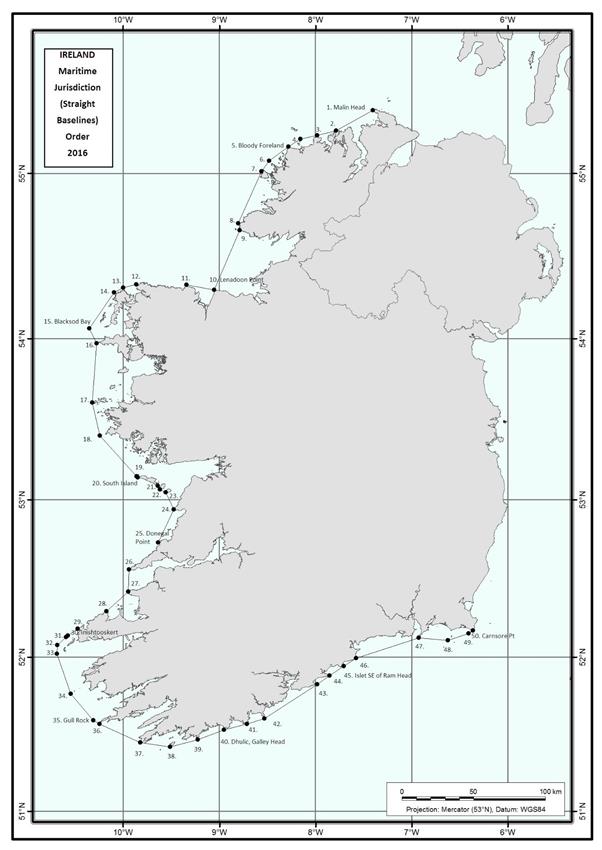
baselines from Malin Head to Carnsore Point.
The new Order has been made following the
resurvey of the 50 basepoints used in the 1959 system of straight baselines, employing
modern geodetic surveying techniques. The position of each basepoint is now recorded
in coordinates of latitude and longitude accurate to 5 decimal places on the
World Geodetic System 84 (WGS 84) datum.
The new Order (the Maritime
Jurisdiction (Straight Baselines) Order 2016 (S.I. No. 22 of 2016)) replaces the Maritime
Jurisdiction (Straight Baselines) Order 1959 (S.I. No. 173 of 1959) and comes into operation
on 1 February 2016. There is no change to the straight baselines system itself.
The coordinates of each basepoint are
set out below, together with an illustrative map:
Reference No. |
Latitude |
Longitude |
Description |
Part A |
1 |
55° 22' 32.87293" N |
7° 24' 09.48168" W |
Scart Rocks, Malin Head |
2 |
55° 15' 26.04254" N |
7° 47' 14.42085" W |
Melmore Head |
3 |
55° 13' 40.78997" N |
7° 59' 01.05940" W |
Horn Head |
4 |
55° 12' 24.12915" N |
8° 09' 37.21957" W |
Inishbeg |
5 |
55° 09' 35.96316" N |
8° 17' 01.89121" W |
Bloody Foreland |
6 |
55° 04' 32.10846" N |
8° 28' 52.19132" W |
Stag Rocks |
7 |
55° 00' 54.63951" N |
8° 33' 42.21630" W |
Rinrawros Point, Aran Island |
8 |
54° 41' 57.38032" N |
8° 48' 25.53870" W |
Malinmore Head |
Part B |
9 |
54° 39' 35.12589" N |
8° 47' 19.10427" W |
Malinbeg Bay, West Entrance |
10 |
54° 17' 41.73725" N |
9° 03' 29.60920" W |
Lenadoon Point |
11 |
54° 19' 39.88447" N |
9° 20' 44.99838" W |
Downpatrick Head |
Part C |
12 |
54° 19' 49.50515" N |
9° 51' 55.26154" W |
Kid Island, Broadhaven |
13 |
54° 18' 39.55771" N |
9° 59' 55.29010" W |
Erris Head |
14 |
54° 17' 04.53378" N |
10° 05' 30.12885" W |
Eagle Island |
15 |
54° 03' 38.17630" N |
10° 21' 00.96420" W |
Blacksod Bay (rock SW of
Black Rock) |
16 |
53° 58' 19.82759" N |
10° 16' 25.13030" W |
Carrickakin, Achill Island |
17 |
53° 36' 11.87952" N |
10° 18' 52.11944" W |
Kimmeen Rocks, Inishark |
18 |
53° 24' 01.03246" N |
10° 14' 25.06583" W |
Slyne Head |
19 |
53° 08' 45.34880" N |
9° 51' 31.37033" W |
Eeragh Island, Aran Islands |
20 |
53° 08' 26.54765" N |
9° 50' 59.44841" W |
South Island, Aran Islands |
Part D |
21 |
53° 05' 18.44451" N |
9° 38' 25.42724" W |
S.E. corner Inishmore, Aran
Islands |
22 |
53° 03' 56.50713" N |
9° 37' 01.66646" W |
Inishmaan, Aran Islands |
23 |
53° 02' 51.97453" N |
9° 33' 16.66174" W |
Inisheer, Aran Islands |
24 |
52° 56' 20.82657" N |
9° 28' 34.97449" W |
Cregga More |
25 |
52° 43' 43.82360" N |
9° 38' 03.41970" W |
Donegal Point |
Part E |
26 |
52° 33' 32.72760" N |
9° 56' 18.05722" W |
Loop Head |
27 |
52° 25' 12.69702" N |
9° 56' 42.01840" W |
Kerry Head |
28 |
52° 17' 29.37530" N |
10° 10' 34.66357" W |
Deelick Point
|
Part F |
29 |
52° 10' 55.20606" N |
10° 28' 17.22205" W |
Sybil Point |
30 |
52° 08' 15.36584" N |
10° 34' 25.66524" W |
Inishtooskert, Blasket
Islands |
31 |
52° 07' 30.35819" N |
10° 35' 45.37947" W |
Carrigduff, Blasket Islands |
32 |
52° 04' 29.84284" N |
10° 40' 45.80315" W |
Tearaght Rocks West,
Inistearaght |
33 |
52° 01' 26.84347" N |
10° 41' 26.28472" W |
Great Foze Rocks |
34 |
51° 45' 53.26444" N |
10° 32' 49.16890" W |
Washerwoman Rock, Great
Skellig |
35 |
51° 35' 31.66824" N |
10° 18' 28.34177" W |
Gull Rock, Dursey Island |
36 |
51° 34' 12.52557" N |
10° 14' 53.40665" W |
The Calf, Dursey Island |
37 |
51° 26' 56.91703" N |
9° 49' 16.50803" W |
Mizen Head |
38 |
51° 25' 12.45597" N |
9° 30' 50.31146" W |
Bream Point, Cape Clear |
39 |
51° 27' 59.40209" N |
9° 13' 27.99594" W |
Strologue, Toe Head – Stags |
40 |
51° 31' 46.05211" N |
8° 57' 08.79434" W |
Dhulic, Galley Head |
41 |
51° 34' 09.50390" N |
8° 42' 49.00104" W |
Seven Heads |
42 |
51° 36' 14.30752" N |
8° 32' 04.12550" W |
Old Head of Kinsale |
43 |
51° 49' 28.32329" N |
7° 59' 01.82870" W |
Ballycotton Island |
44 |
51° 52' 51.33027" N |
7° 51' 15.64324" W |
Knockadoon Head, Capel Island |
45 |
51° 56' 30.43116" N |
7° 42' 29.04668" W |
Islet SE of Ram Head |
46 |
51° 59' 41.77191" N |
7° 34' 38.73414" W |
The Rogue, Mine Head |
47 |
52° 07' 21.90213" N |
6° 55' 48.89945" W |
Hook Head |
48 |
52° 06' 31.42349" N |
6° 37' 23.30526" W |
South end of Great Saltee
Island |
49 |
52° 09' 17.21990" N |
6° 24' 48.79233" W |
Black Rock, Carnsore |
50 |
52° 10' 20.74906" N |
6° 21' 51.75365" W |
Carnsore Point |
Irish
Maritime Administration,
Department
of Transport, Tourism and Sport,
Leeson
Lane, Dublin 2, D02 TR60, Ireland.